As the more colorful weather forecasters would say, winter still has its icy grip on us! A new storm is forecast to impact the Midwest, Southeast and East this week, while we in the west are finally getting serious rain! Which brings us to the topic of freezing rain. The city of Atlanta was brought to its knees a few weeks ago courtesy of freezing rain and other winter precipitation. And then just two weeks later the same happened in Rayleigh, NC! I guess they didn’t watch the news from Atlanta! So what is this mysterious thing called freezing rain? How does it form and why does it wreak so much havoc?
Let’s start by talking about supercooled water. In school we learn that water freezes at 32oF (which is the same as 0oC or 273K). But really – it doesn’t, or at least not necessarily, and certainly not necessarily in the atmosphere! If we take highly purified water droplets in a laboratory and cool them down, they can remain liquid – in other words unfrozen – down to temperatures reportedly as low as -55oF (read this report)! What this illustrates is the fact that it is very difficult for water to spontaneously freeze! Instead, the liquid droplets need help for freezing to take place. In the case of a liquid water droplet in a cloud, impurities in the water may play the role of “seeds” around which liquid water can freeze. These “seeds” spark the process whereby the water molecules crystallize and form an organized lattice structure (i.e., ice). Examples of these impurities include dust, soot, and bacteria!
Supercooled liquid droplets can also freeze when they come into contact with a surface, and that’s where problems start for us. A well-known example involves aircraft icing. This is where supercooled droplets freeze onto the leading edge of the wing of an aircraft as the airplane flies through the cloud. Ice therefore deposits onto the wings, and changes the aerodynamic properties of the airplane. The ice can make a stall more likely (unless the pilot adjusts for it) – and nobody wants to be in an aircraft when it stalls in midair! To cope with this, larger aircraft have heaters on the wings to prevent ice build-up. This is also why your aircraft is de-iced before takeoff when meteorological conditions are favorable for icing to occur. You’ll notice that aircraft de-icing is a winter event! De-icing is rare in coastal California, but a very cold air outbreak in early December 2013 meant that San Jose airport had to haul out its de-icing equipment (SJ Mercury new article).
A second way in which supercooled water can impact us is via a freezing rain storm. There have been a number of these this year (east of the Rockies), so let’s see what happens. The process of forming rain or snow is generally very complex. Inside a cloud we often find a mixture of ice crystals, liquid water droplets, and supercooled liquid droplets. This mixture is being stirred by air motions within the cloud, and of course the cloud itself is usually moving with a storm system! Around and inside the cloud, various transformation processes may be underway: near the edges of the cloud, liquid cloud droplets might be evaporating into the surrounding clear air. Inside the cloud, ice crystals might be growing, but some may also be melting; some liquid droplets may be freezing, while others remain supercooled. As you can see, life is very complicated inside a cloud!!
It is well-established – but perhaps not well-known – that in our latitudes and especially in winter, precipitation starts in the form of snow! So the raindrops that fall on your head may have been snowflakes a few minutes earlier up in the cloud! Ground-level temperatures in coastal California are rarely below freezing, so that snowflakes simply melt on the way down. This is the “normal” situation, and occurs whenever air temperatures get colder the higher up we go in the atmosphere (as is usually the case).
However – it is sometimes possible to get layers of air that are alternately warmer or colder “stacked” on top of each other in the atmosphere, and this is when the fun starts! Freezing rain happens when the air high up is cold enough that snow falls from clouds. If there is a layer of “warm” air below the cloud, the snow will melt to form raindrops. Sometimes there can also be another layer of “cold” air below the layer of “warm” air – remember that the atmosphere can be very complicated! The melted snowflakes can re-freeze as they fall through this cold layer. If the cold layer is deep enough, we experience a fall of small ice pellets from the sky – this is called sleet in America (but in England, “sleet” refers to a mixture of wet snowflakes and rain drops, and obviously happens when the air temperature is right around freezing. Sleet of this nature is quite common in the UK!)
Back to our layers…freezing rain happens when that lowest layer of cold layer is shallow. Recall that snowflakes have fallen from the cloud, have melted into liquid drops below the cloud, and are still falling (gravity!) They now fall into this shallow cold layer right above the ground, and start to cool down again. They become supercooled, but since the layer is shallow, the process of freezing doesn’t have time to complete – and hence we get supercooled droplets hitting the ground! And as soon as these supercooled droplets hit something, they freeze!
Here’s a link to a nice animated cartoon of how these types of precipitation (snow, sleet, or freezing rain) form – take a look!
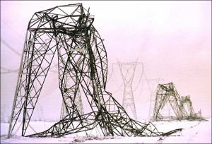
What can our supercooled droplets freeze onto? How about power lines! As a result of this, power lines get coated with ¼” or more of solid ice, as the photos below show. The added weight is usually enough to bring down the lines and poles. If just one line goes out, it gets fixed fast, but when an ice storm brings down ALL the power lines in your town, you’re gonna be without power for some time. In a huge ice storm that hit Quebec in 1998, even the largest power transmission towers came down (see the photo below).
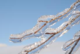
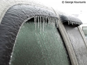
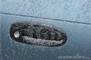
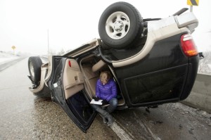
Freezing rain also forms a layer of ice on trees, adding extra weight to branches and causing them to snap off. They too fall on and bring down power lines, so now you have no power AND the roads are blocked by downed trees. Freezing rain also forms a sheet of ice on the roads themselves – this makes driving quite challenging as your tires completely lose their grip on the road! And in any case – and in my personal experience – it’s tough to even get in your car since it is coated with ice when you try to get in it! In a keyed car the keyhole is iced over! And if you can get the key in the car, the doors are iced shut and you can’t open them! And if you can get the doors open and get in, the wipers are frozen to the windows! And if you can manage to get the car moving, you probably can’t stop! The fun never ends with a freezing rainstorm! We in lowland California should be grateful that we don’t get these storms, and if you’re ever visiting back east in winter and one of these storms hits – stay indoors!
Below is a series of photos showing just some impacts of freezing rain. And here’s a short video of somebody trying to get into their iced-over car with a hammer!
