January 26, 2014 – and still no rain has fallen in what should be one of our rainiest months. As of today, we’ve gone 50 DAYS since the last measurable rain in San Jose – incredible!!! Incredible given that December and January are the peak rain months for us.
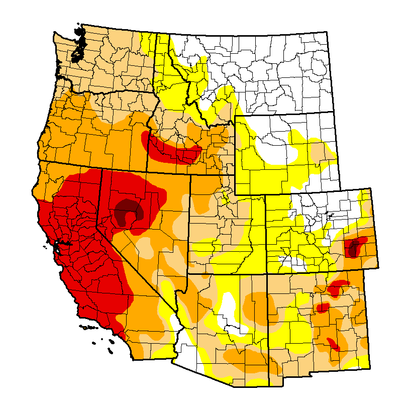
Severe drought has been declared in the west, as shown in this graphic (red means extreme drought, dark red (Nevada) is exceptional drought):
Impacts of the drought are all around us. This link shows a gallery of photos of area reservoirs and lakes, some of which are almost empty! Word is also spreading about the drought. Although we in the Department of Meteorology & Climate Science have been talking about the lack of rain since around Thanksgiving, it’s only in the last 1-2 weeks that the rest of the nation have started to notice. Not surprising given the “polar vortex” and relentless cold weather back east. Here’s how the BBC (in England) sees it.
Why do we care? For those of us in urban areas who rely on water from the faucet for showers, cooking etc., think about where this water comes from… According to the San Jose Water Company: 50% of our water supply is imported and mainly originates as snow melt from the Sierras; 40% originates from local groundwater sources; and 10% is from reservoirs which capture rain in the Santa Cruz mountains.
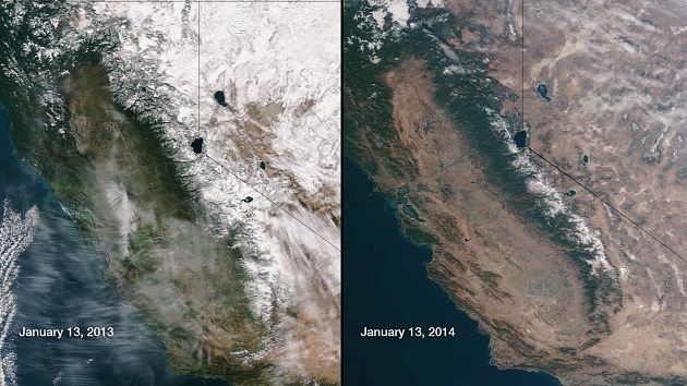
As the photo below shows, there is very little snow pack in the Sierras right now, way less than is typical for this time of year. The satellite image on the right shows how things looked on 13 Jan, but is more reminiscent of late spring, when the only snow left is at the highest elevations, i.e., after the spring melt.
So – the “50% of local water” certainly looks to be in serious jeopardy. What about the “40% from groundwater”? “We’re not panicking” says the local water agency.
Is there any hope of change? Yes! First, a quick review. As I explained in this post, our flow pattern has now been locked in place for an incredible two months (roughly). The pattern has consisted of a strong ridge of high pressure over the west coast, and a companion trough of low pressure east of the Rockies. The western ridge has blocked rain-bearing storms from California, and has resulted in mild settled weather. In fact, “mild” is an understatement as many high temperature records have fallen in the west. Local NWS offices have been posting these online, including from Sacramento and San Francisco/Monterey Bay.
We’ve continued to experience a record number of “Spare the Air” days as slack winds cannot scour the air clear of pollutants. Much as we complain in the Bay Area, it seems to be worse in the Central Valley. East of us, the strong trough is still bringing wave after wave of very cold air and fresh snow. And west of us? The strong ridge steers storms north towards Alaska, but more significantly should be steering warm air north towards Alaska too, so we should expect to find stories about “unusual warmth” in AK. And sure enough…record warmth expected in Fairbanks! Of course, that means a high of just 40F! Rain fell along the (normally ice-cold) north slope of AK in December – very rare!
What do the forecast models predict? Remember what we said in this blog about how we use models to forecast, and whether or not they are reliable. In that post, written on 8 Jan, the models predicted rain for 21 Jan – and that didn’t pan out did it! However, for several days now all models have been hinting at rain at the end of this week, AND a “pattern change”. This simply means that the “strong western ridge + deep eastern tough” pattern is forecast to break down. For storms and rain in the west, we need a trough to set up, and the models ARE predicting this! Further east, the deep trough is forecast to relax, which will bring an end to the bitter cold by the end of the week.
So there is at least a little hope in sight! In the long term? As we discussed, forecasts beyond 10-14 days have little skill, so it’s not possible to say – with any confidence – whether the “pattern change” will stay, or whether the atmosphere will revert back to where it’s been for the last two months.
As far as San Jose rain is concerned, think about this: suppose we get a quarter of an inch of rain every day in February. This would be more than a daily light rain shower, but less than a continuous downpour. At the end of February we would have received 7 inches of new rain – roughly half of what we get annually on average. This would certainly help! Heavy rain tends to fall so quickly that a lot runs off into the storm drains and out to the Bay. Thus we need moderate or steady rain that can soak into the groundwater storage system. In addition, if we were to get a series of “warm storms”, with relatively mild temperatures, the Sierras would receive more rain than snow – snow is preferred so that the reservoirs can fill up during the melt season.
So – keep you eyes glued to the forecast products, and cross your fingers that we get a pattern change which ushers in a strong of storms bringing rain to the lowlands, and snow to the mountains!